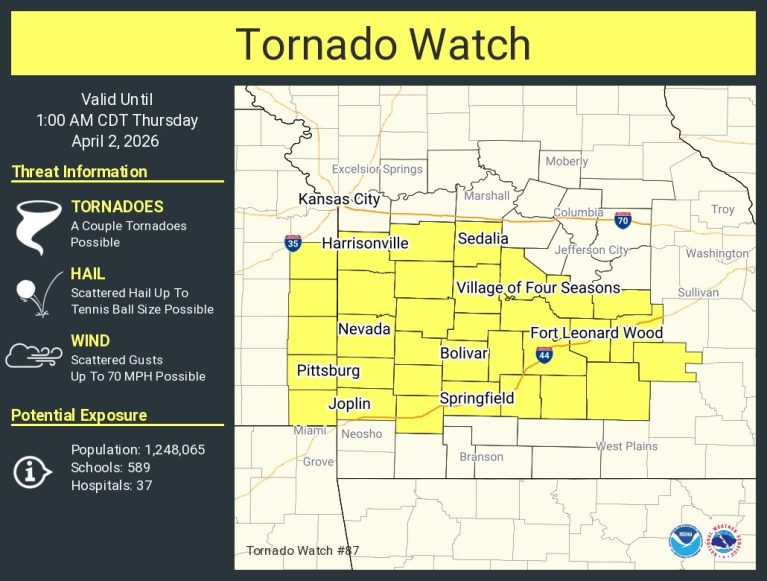
Tornado Watch In Effect Until 1AM
A tornado watch has been issued for parts of Kansas and Missouri until 1 AM CDT
Also,
…FLOOD WATCH IN EFFECT FROM 7 PM CDT THIS EVENING THROUGH THURSDAY AFTERNOON…
* WHAT…Flooding caused by excessive rainfall is possible.
* WHERE…Portions of southeast Kansas, including the following area, Bourbon and Missouri, including the following areas, Benton, Morgan, St. Clair and Vernon.
* WHEN…From 7 PM CDT this evening through Thursday afternoon.
* IMPACTS…Excessive runoff may result in flooding of rivers, creeks, streams, and other low-lying and flood-prone locations. Creeks and streams may rise out of their banks.
* ADDITIONAL DETAILS…
– Widespread rainfall amounts of 1-2 inches with localized amounts of 3-5 inches can be expected overnight into Thursday morning.
PRECAUTIONARY/PREPAREDNESS ACTIONS…
You should monitor later forecasts and be alert for possible Flood Warnings. Those living in areas prone to flooding should be prepared to take action should flooding develop.

Reporter John Rogger