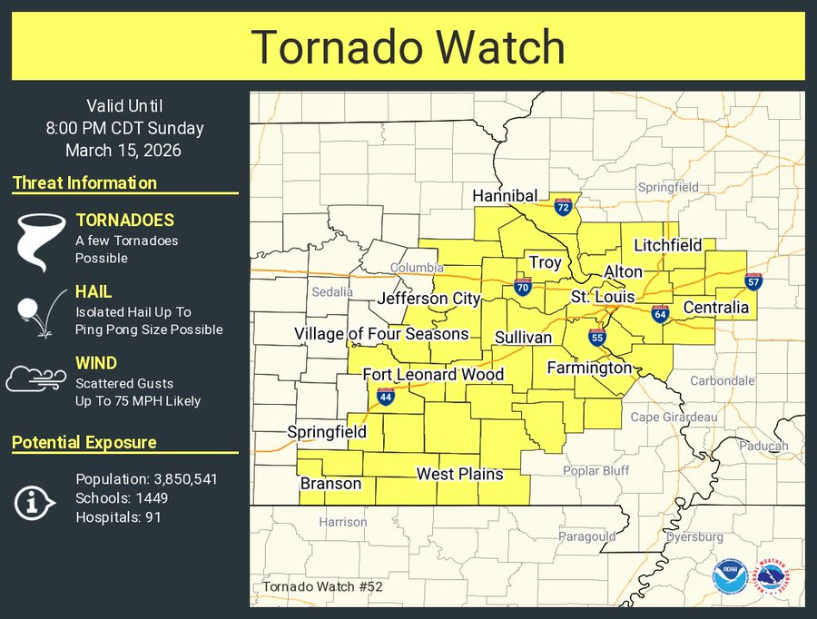
SEVERE WEATHER ALERTS IN EFFECT ACROSS THE LAKE AREA
Current Warnings:
Severe Thunderstorm Warning including Southern Pulaski County….until 3:45 PM CDT

The National Weather Service in Springfield has issued a
* Severe Thunderstorm Warning for…
Shannon County in south central Missouri…
Wright County in southwestern Missouri…
Douglas County in southwestern Missouri…
Dent County in south central Missouri…
Northern Howell County in south central Missouri…
Southeastern Pulaski County in central Missouri…
Texas County in south central Missouri…
Southwestern Phelps County in east central Missouri…
Northwestern Oregon County in south central Missouri…
* Until 345 PM CDT.
* At 256 PM CDT, severe thunderstorms were located along a line extending from 12 miles west of Licking to 7 miles north of Cabool to 12 miles southeast of Ava, moving east at 45 mph.
HAZARD…60 mph wind gusts and penny size hail.
SOURCE…Radar indicated.
IMPACT…Expect damage to roofs, siding, and trees.
* Locations impacted include… Southeastern Fort Leonard Wood, Ozark National Scenic Riverways, Echo Bluff State Park, Current River State Park, Montauk State Park, Bryant Creek State Park, Salem, Mountain Grove, Licking, Ava, Mountain View, Willow Springs, Cabool, Houston, Winona, Mansfield, Dawson, Birch Tree, Norwood, and Hartville.
PRECAUTIONARY/PREPAREDNESS ACTIONS…
Remain alert for a possible tornado! Tornadoes can develop quickly
from severe thunderstorms. If you spot a tornado go at once into the basement or small central room in a sturdy structure.
For your protection move to an interior room on the lowest floor of a building.
A Tornado Watch remains in effect until 800 PM CDT for south central, central, southwestern and east central Missouri.
-o-
Current Watches:
Tornado Watch for the Lake Areas of Camden, Laclede, Pulaski, Miller & Maries….until 8PM


Reporter John Rogger