Severe Weather Warnings In Effect
Severe Warnings:

…A SEVERE THUNDERSTORM WARNING REMAINS IN EFFECT UNTIL 1230 AM CST
FOR WEBSTER…SOUTHERN DALLAS…NORTHWESTERN WRIGHT…NORTHWESTERN
DOUGLAS…CHRISTIAN…WESTERN LACLEDE…SOUTHEASTERN POLK…NORTHERN
STONE AND GREENE COUNTIES…
At 1148 PM CST, severe thunderstorms were located along a line
extending from 8 miles east of Buffalo to 7 miles east of Fair Grove
to near Highlandville to near Galena, moving northeast at 60 mph.
HAZARD…60 mph wind gusts and penny size hail.
SOURCE…Radar indicated.
IMPACT…Expect damage to roofs, siding, and trees.
Locations impacted include…
Springfield, Nixa, Ozark, Republic, Lebanon, Bennett Spring State
Park, Marshfield, Battlefield, Willard, Buffalo, Rogersville,
Strafford, Clever, Seymour, Sparta, Morgan, Crane, Fair Grove,
Billings, and Highlandville.
This includes Interstate 44 between mile markers 61 and 143.
PRECAUTIONARY/PREPAREDNESS ACTIONS…
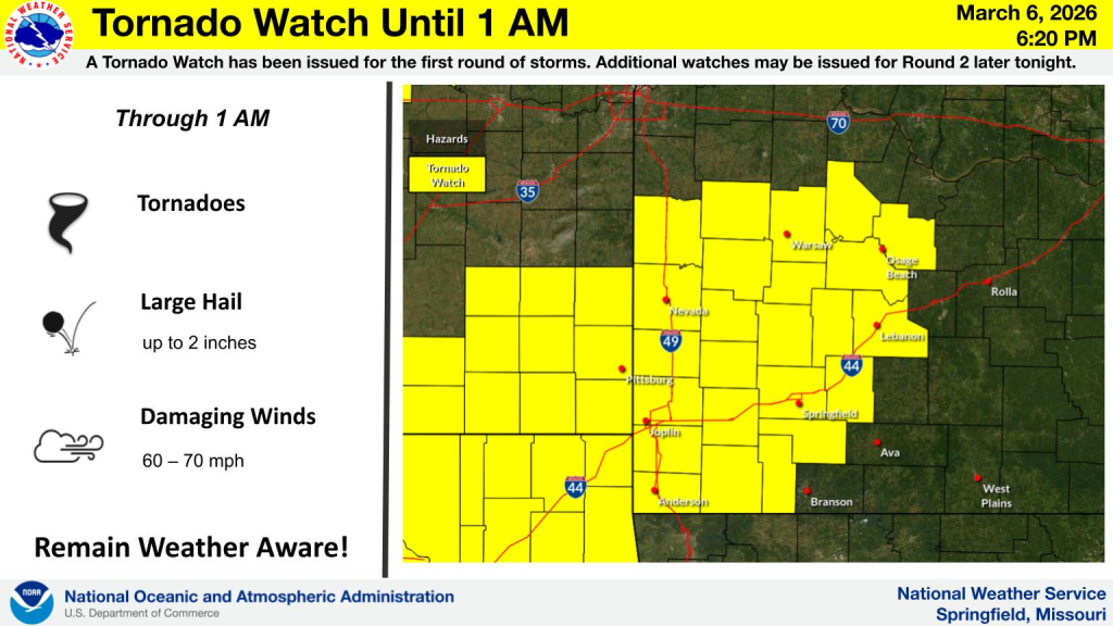
A Tornado Watch remains in effect until 100 AM CST for central and
southwestern Missouri.
Remain alert for a possible tornado! Tornadoes can develop quickly
from severe thunderstorms. If you spot a tornado go at once into the
basement or small central room in a sturdy structure.
For your protection move to an interior room on the lowest floor of a
building.
-o-

Flash Flood Warning including Bolivar MO, Buffalo MO and Ash Grove MO until 6:00 AM CST
The National Weather Service in Springfield has issued a
* Flash Flood Warning for…
Southeastern Camden County in central Missouri…
Southeastern Cedar County in southwestern Missouri…
Eastern Dade County in southwestern Missouri…
Northern Dallas County in southwestern Missouri…
Northwestern Greene County in southwestern Missouri…
Southeastern Jasper County in southwestern Missouri…
Northwestern Laclede County in southwestern Missouri…
Northwestern Lawrence County in southwestern Missouri…
Polk County in southwestern Missouri…
* Until 600 AM CST Saturday.
* At 1155 PM CST, Doppler radar indicated thunderstorms producing
heavy rain across the warned area. Between 1 and 3 inches of rain
have fallen. Additional rainfall amounts up to 1 inch are possible
in the warned area. Flash flooding is ongoing or expected to begin
shortly.
HAZARD…Flash flooding caused by thunderstorms.
SOURCE…Radar.
IMPACT…Flash flooding of small creeks and streams, urban
areas, highways, streets and underpasses as well as
other poor drainage and low-lying areas.
* Some locations that will experience flash flooding include…
Bolivar, Buffalo, Greenfield, Ash Grove, Sarcoxie, Miller, Walnut
Grove, Fair Play, Morrisville, Everton, Polk, Fidelity, Dadeville,
Stotts City, Halfway, Bennett Springs, Avilla, Louisburg, La
Russell, Reeds, South Greenfield, Aldrich, Eudora, Brighton,
Masters, Bearcreek, Goodson, Cane Hill, Foose, Pumpkin Center,
Pennsboro, Plad, Tunas, Windyville, Leadmine, Red Oak, Dudenville,
Maple Grove, Eldridge and Decaturville.
PRECAUTIONARY/PREPAREDNESS ACTIONS…
Turn around, don`t drown when encountering flooded roads. Many flood
deaths occur in vehicles.
Be aware of your surroundings and do not drive on flooded roads.

Reporter John Rogger