More Severe Weather Expected On Saturday Following Thursday’s Storms
A number of severe storms hit the lake area overnight (Thursday) as a large line of storms moved through the entire Midwest region.
Most of the activity was in Benton County, with some storms in Morgan and another round that hit Maries, Pulaski and Phelps counties.
There have been no reports of any significant damage from the storms.
The same system however brought an entire Tornado outbreak for several states, including Illinois, Indiana and Michigan, some of which damaged over 400 homes as of this morning.
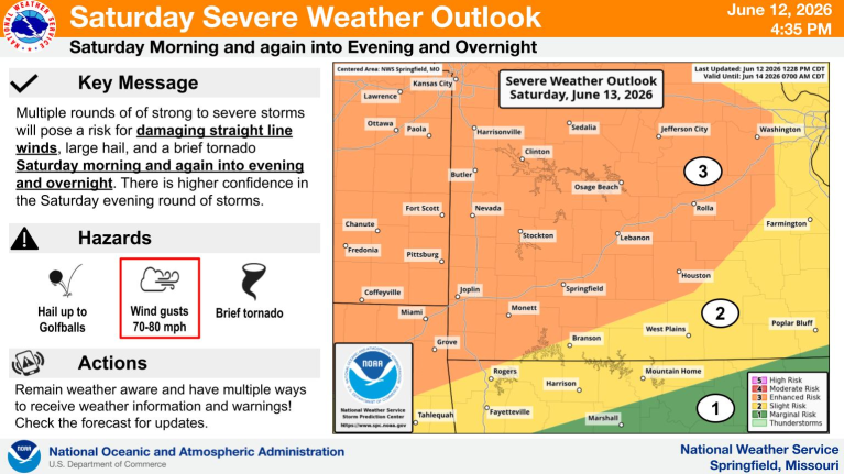
Officials with the National Weather Service say the risk of Tornadoes, Winds up to 80MPH and Ping Pong Ball sized hail is in the forecast for Saturday, with most of the lake region currently in a level 3 enhanced risk.
As of right now, there is a Flood Watch in effect for the Lake area…details on that can be seen below:
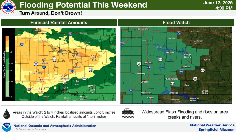
…FLOOD WATCH IN EFFECT FROM 1 AM CDT SATURDAY THROUGH SUNDAY MORNING…
* WHAT…Flooding caused by excessive rainfall continues to be possible.
* WHERE…Portions of central and southwest Missouri, including the following counties, in central Missouri, Camden, Maries, Miller,
Morgan and Pulaski. In southwest Missouri, Dallas and Laclede.
* WHEN…From 1 AM CDT Saturday through Sunday morning.
* IMPACTS…Excessive runoff may result in flooding of rivers, creeks, streams, and other low-lying and flood-prone locations. Flooding may occur in poor drainage and urban areas. Low-water crossings may be flooded. Area creeks and streams are running high
and could flood with more heavy rain.
* ADDITIONAL DETAILS…
– Several rounds of showers and thunderstorms are forecast to move through the area tonight and Saturday bringing a widespread 2 to 4 inches of rain with locally higher amounts.
– http://www.weather.gov/safety/flood
PRECAUTIONARY/PREPAREDNESS ACTIONS…
You should monitor later forecasts and be alert for possible Flood Warnings. Those living in areas prone to flooding should be prepared to take action should flooding develop.

Reporter John Rogger