Severe Weather Moving into the Lake Area
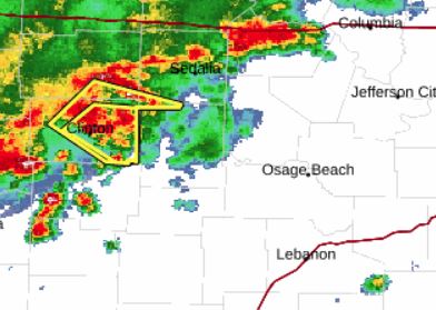
BULLETIN - IMMEDIATE BROADCAST REQUESTED
Severe Thunderstorm Warning
National Weather Service Springfield MO
711 PM CDT Wed Sep 9 2026

The National Weather Service in Springfield has issued a

* Severe Thunderstorm Warning for...
  Benton County in central Missouri...
* Until 800 PM CDT.
* At 711 PM CDT, a severe thunderstorm was located over Calhoun, or 8
  miles southwest of Windsor, moving east at 35 mph.

  HAZARD...60 mph wind gusts and penny size hail.

  SOURCE...Radar indicated.

  IMPACT...Expect damage to roofs, siding, and trees.

* Locations impacted include...
  Truman Lake, Truman State Park, Warsaw, Lincoln, Cole Camp, Ionia,
  Palo Pinto, Lakeview Heights, Brandon, Crockerville, Zora, Knobby,
  Racket, Edwards, Edmonson, Mora, Hastain, and Whitakerville.

PRECAUTIONARY/PREPAREDNESS ACTIONS...

For your protection move to an interior room on the lowest floor of a
building.

Reporter Mike Anthony