Lake Area Prepares For An Unfathomable Amount Of Snow & Cold Temps
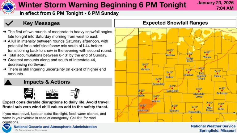 A winter storm warning is now in effect for the entire Lake Region.
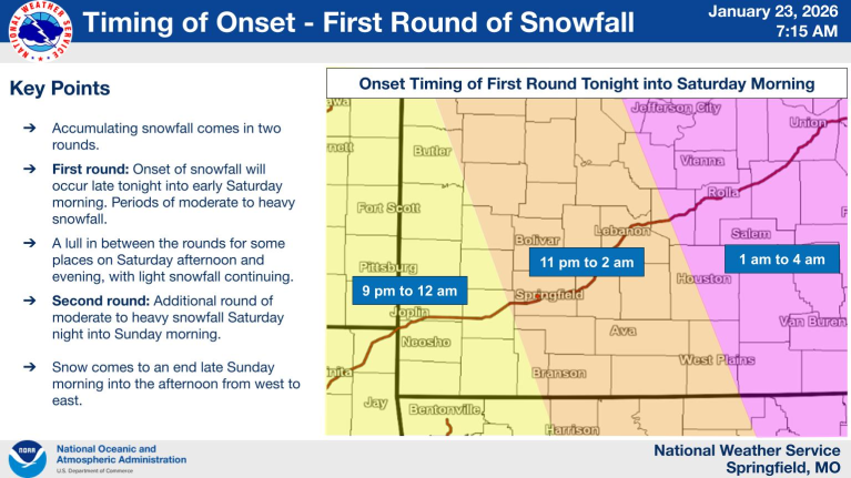
Conditions will be favorable for intense winter weather, including high snow accumulations, that continue to change as the system gets closer.
“Originally it was 3 to 8 and then now it’s like 8 to 13. I’m still thinking 7 to 10 will probably be the most likely. Just be sure that you are just prepared for snow altogether,” says Meteorologist Cara Foster with Weatherology.
She also says we are also looking at seriously cold wind chills, “A cold weather advisory does begin tonight. Wind chills are around 8 below and that goes until Monday at noon, so that’s going to be the coldest portions.”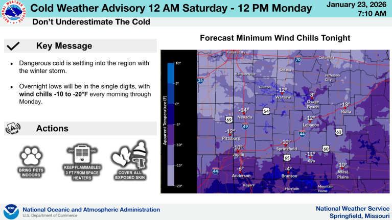
An extreme cold warning is also going into effect through the weekend, which could keep road conditions from improving, and may result in additional closings and cancellations from businesses, non-profits and schools.
A list of all closings in the region can be found on our closings page.
Here’s more information from the National Weather Service.
…WINTER STORM WARNING NOW IN EFFECT FROM 9 PM THIS EVENING TO 6 PM CST SUNDAY…
* WHAT…Heavy snow expected. Total snow accumulations between 6 and 13 inches.
* WHERE…Portions of southeast Kansas and central, east central, south central, southwest, and west central Missouri.
* WHEN…From 9 PM this evening to 6 PM CST Sunday.
* IMPACTS…Travel could be very difficult to impossible.
PRECAUTIONARY/PREPAREDNESS ACTIONS…
If you must travel, keep an extra flashlight, food, and water in your vehicle in case of an emergency. In Missouri, call 1-888-275-6636 for road conditions.
—o—
…EXTREME COLD WARNING REMAINS IN EFFECT FROM MIDNIGHT TONIGHT TO NOON CST MONDAY…
* WHAT…Dangerously cold wind chills of 5 below to colder than 15 below zero expected.
* WHERE…Portions of central, eastern, north central, southeast, southwest, and western Arkansas.
* WHEN…From midnight tonight to noon CST Monday.
* IMPACTS…Dangerously cold wind chills as low as 10 below zero could result in hypothermia if precautions are not taken. Frostbite and hypothermia will occur if unprotected skin is exposed to these temperatures. An extended period of freezing temperatures could cause ruptured water pipes.
PRECAUTIONARY/PREPAREDNESS ACTIONS…
Dress in layers including a hat, face mask, and gloves if you must go outside.
To prevent water pipes from freezing; wrap or drain or allow them to drip slowly.
Keep pets indoors as much as possible.
Make sure outdoor animals have a warm, dry shelter, food, and unfrozen water.
Make frequent checks on older family, friends, and neighbors. Ensure portable heaters are used correctly. Do not use generators or grills inside.
—o—
…COLD WEATHER ADVISORY REMAINS IN EFFECT FROM MIDNIGHT TONIGHT TO NOON CST MONDAY…
* WHAT…Very cold wind chills as low as 17 below expected.
* WHERE…Portions of southeast Kansas and central, east central, south central, southwest, and west central Missouri.
* WHEN…From midnight tonight to noon CST Monday.
* IMPACTS…The cold wind chills as low as 15 below zero could result in hypothermia or frostbite if precautions are not taken.
PRECAUTIONARY/PREPAREDNESS ACTIONS…
Use caution while traveling outside. Wear appropriate clothing, a hat, and gloves.

Reporter John Rogger