Lake Area Under Winter Storm Advisory/Warning As Snow Approaches
The Lake of the Ozarks is right smack in the middle of the action with the latest winter storm.
Weather officials say we could see anywhere from 2 to 9 inches of snow, depending on where you live along the storm boundaries.
With that, the National Weather Service has issued 2 storm advisories for the community….with Camden, Miller, Morgan and Benton Counties falling into the “Winter Storm Advisory” and areas to the south, including Pulaski, Laclede and Maries Counties seeing a Winter Storm Warning.
Snow is expected to start falling in the Camdenton portion of the lake around 8PM with the heaviest falling between 11PM and 3AM into Wednesday Morning.
Any closings or cancellations will be listed on our closings section of the website beginning at 6AM tomorrow morning. If you have a closing to report, please e-mail it to newsroom@krmsradio.com
Below is the details on the Warnings and Advisories.
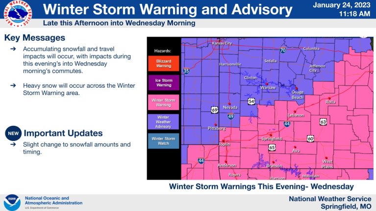
Benton, Camden, Miller, Morgan, Hickory

...WINTER WEATHER ADVISORY REMAINS IN EFFECT FROM 9 PM THIS EVENING
TO NOON CST WEDNESDAY...

* WHAT...Snow expected. Total snow accumulations between 3 and 5
  inches with locally heavier amounts up to 6 inches. A sharp
  gradient in snowfall amounts is likely in this area.

* WHERE...A portion of central Missouri.

* WHEN...From 9 PM this evening to Noon CST Wednesday.

* IMPACTS...Roads, and especially bridges and overpasses, will
  likely become slick and hazardous. Travel could be very difficult.
  The hazardous conditions could impact the Wednesday morning
  commute.

PRECAUTIONARY/PREPAREDNESS ACTIONS...

Slow down and use caution while traveling. Call 1-888-275-6636 for
road conditions.

-o-
Maries-Pulaski-Phelps-Laclede
...WINTER STORM WARNING REMAINS IN EFFECT FROM 6 PM THIS EVENING TO
NOON CST WEDNESDAY...

* WHAT...Heavy snow expected. Total snow accumulations between 6 and
  10 inches with locally heavier amounts up to 12 inches.

* WHERE...Portions of central, east central, south central, and
  southwest Missouri.

* WHEN...From 6 PM this evening to Noon CST Wednesday.

* IMPACTS...Roads, and especially bridges and overpasses, will
  likely become slick and hazardous. Travel could be very difficult
  to impossible. The hazardous conditions could impact the Tuesday
  evening and Wednesday morning commutes.

PRECAUTIONARY/PREPAREDNESS ACTIONS...

If you must travel, keep an extra flashlight, food, and water in
your vehicle in case of an emergency. Call 1-888-275-6636 for road
conditions.

Persons should consider delaying all travel. If travel is absolutely
necessary, drive with extreme caution. Consider taking a winter
storm kit along with you, including such items as tire chains,
booster cables, flashlight, shovel, blankets and extra clothing.
Also take water, a first aid kit, and anything else that would help
you survive in case you become stranded.

Reporter John Rogger