SEVERE WEATHER INFORMATION IS AT KRMSRADIO.COM
Current Storm Warnings:
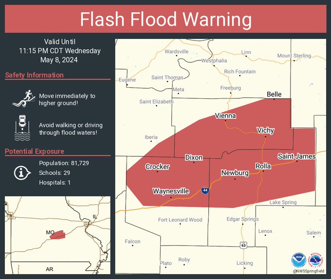
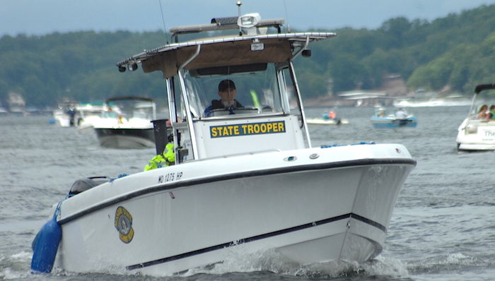
Flash Flood Warning including Rolla MO, Waynesville MO and Saint Robert MO until 11:15 PM CDT
The National Weather Service in Springfield has issued a

* Flash Flood Warning for...
  Maries County in central Missouri...
  Southeastern Miller County in central Missouri...
  Northern Pulaski County in central Missouri...
  Phelps County in east central Missouri...

* Until 1115 PM CDT Wednesday.

* At 510 PM CDT, Doppler radar indicated thunderstorms producing
  heavy rain across the warned area. Between 1 and 3 inches of rain
  have fallen. Additional rainfall amounts up to 1 inch are possible
  in the warned area. Flash flooding is ongoing or expected to begin
  shortly.

  HAZARD...Flash flooding caused by thunderstorms.

  SOURCE...Radar.

  IMPACT...Flash flooding of small creeks and streams, urban
           areas, highways, streets and underpasses as well as
           other poor drainage and low-lying areas.

* Some locations that will experience flash flooding include...
  Rolla, northern Fort Leonard Wood, Waynesville, St. Robert, St.
  James, Richland, Dixon, Belle, Crocker, Doolittle, Vienna,
  Newburg, Jerome, Northwye, Brinktown, Vichy, Devil`s Elbow,
  Rosati, Swedeborg and Ozark Springs.

PRECAUTIONARY/PREPAREDNESS ACTIONS...

Turn around, don`t drown when encountering flooded roads. Many flood
deaths occur in vehicles.
Flood Warnings:

...Forecast flooding changed to Minor severity and increased in
duration for the following rivers in Missouri...

  Maries River near Westphalia.

River forecasts are based on observed precipitation and forecast
precipitation for the next 24 hours.

...FLOOD WARNING NOW IN EFFECT UNTIL EARLY FRIDAY AFTERNOON... * WHAT...Minor flooding is occurring and minor flooding is forecast. * WHERE...Maries River near Westphalia in Osage County * WHEN...Until early Friday afternoon. * IMPACTS...At 14.3 feet, County Road 608 north of the bridge begins flooding near this height. * ADDITIONAL DETAILS... - At 1:01 PM CDT Wednesday the stage was 10.6 feet. - Recent Activity...The maximum river stage in the 24 hours ending at 1:01 PM CDT Wednesday was 10.6 feet. - Forecast...The river is expected to rise to a crest of 14.5 feet this evening. It will then fall below flood stage tomorrow morning. - Flood stage is 10.0 feet. AND
...The National Weather Service in St Louis MO has issued a Flood
Warning for the following rivers in Missouri...

  Osage River near Mari-Osa Campground.

River forecasts are based on observed precipitation and forecast
precipitation for the next 24 hours.
...FLOOD WARNING IN EFFECT FROM THIS EVENING TO LATE SUNDAY
EVENING...

* WHAT...Minor flooding is forecast.

* WHERE...Osage River near Mari-Osa Campground in Osage County.

* WHEN...From this evening to late Sunday evening.

* IMPACTS...At 20.0 feet, Near this stage the lowest two campsites
  at Mari-Osa campground begin flooding.

* ADDITIONAL DETAILS...
  - At 7:00 AM CDT Tuesday, May 07 the stage was 18.6 feet.
  - Forecast...The river will rise above flood stage this evening
    to 19.6 feet tomorrow morning. It will then fall Friday
    morning. It will rise to 19.5 feet Friday evening. It will
    then fall below flood stage Saturday afternoon.
  - Flood stage is 19.0 feet.

AND
...The National Weather Service in St Louis MO has issued a Flood
Warning for the following rivers in Missouri...

  Moreau River near Jefferson City.

River forecasts are based on observed precipitation and forecast
precipitation for the next 24 hours.
...FLOOD WARNING IN EFFECT FROM THIS EVENING TO SATURDAY MORNING...

* WHAT...Minor flooding is forecast.

* WHERE...Moreau River near Jefferson City.

* WHEN...From this evening to Saturday morning.

* IMPACTS...At 23.5 feet, Near this height, Walnut Acres Road near
  North Moreau Creek will likely need to be closed.  This road is
  18.3 river miles upstream of the gage.

* ADDITIONAL DETAILS...
  - At 10:30 AM CDT Wednesday the stage was 7.5 feet.
  - Forecast...The river is expected to rise above flood stage
    this evening to a crest of 23.0 feet early tomorrow
    afternoon. It will then fall below flood stage late tomorrow
    evening.
  - Flood stage is 17.0 feet.
Current Watches:

TORNADO WATCH 212 IS IN EFFECT UNTIL 1200 AM CDT FOR THE
 FOLLOWING LOCATIONS

    MISSOURI COUNTIES INCLUDED ARE

BARRY                BOLLINGER           BUTLER
CAPE GIRARDEAU       CARTER              CHRISTIAN
CRAWFORD             DENT                DOUGLAS
FRANKLIN             GASCONADE           GREENE
HOWELL               IRON                JEFFERSON
LACLEDE              MADISON             MISSISSIPPI
NEW MADRID           OREGON              OZARK
PERRY                PHELPS              PULASKI
REYNOLDS             RIPLEY              SCOTT
SHANNON              ST. FRANCOIS        STE. GENEVIEVE
STODDARD             STONE               TANEY
TEXAS                WASHINGTON          WAYNE
WEBSTER              WRIGHT
-o-
Flood Watch Until Midnight….
...FLOOD WATCH IN EFFECT FROM 10 AM CDT THIS MORNING THROUGH MIDNIGHT....
Benton-Morgan-Miller-Maries-St. Clair-Hickory-Camden-Pulaski-
Phelps-Cedar-Polk-Dallas-Laclede-Texas-Dent-Webster-Wright-
Shannon-
Including the cities of Versailles, Vichy, Mansfield,
Decaturville, Caplinger Mills, Buffalo, Marshfield, Charity,
Bangert, Lebanon, Gladden, Crockerville, Winona, Lynchburg,
Graff, Lake Spring, Jadwin, Fort Leonard Wood, Montier, Lincoln,
Filley, Northview, Seymour, Mora, Laurie, Quincy, Osage Beach,
Cedar Springs, Bolivar, Foose, Appleton City, Whitakerville,
Weaubleau, Darien, Aurora Springs, Lake Ozark, Pittsburg,
Rogersville, Rocky Mount, Warsaw, Village of Four Seasons,
Stockton, Cross Timbers, Plad, Olive, Plato, Birch Tree, Stover,
Roach, Windyville, Bendavis, Camdenton, Roby, Rolla, Teresita,
Dawson, Edmonson, Tiffin, Johnson City, Arnica, Salem, Eldon,
Waynesville, El Dorado Springs, Mountain Grove, Duncan,
Wheatland, Cole Camp, Hermitage, Laquey, Northwye, March, Howes,
and Huggins
244 AM CDT Wed May 8 2024

...FLOOD WATCH IN EFFECT FROM 10 AM CDT THIS MORNING THROUGH THIS
EVENING...

* WHAT...Flash flooding caused by excessive rainfall is possible.

* WHERE...Portions of central, east central, south central,
  southwest, and west central Missouri, including the following
  areas, in central Missouri, Benton, Camden, Hickory, Maries,
  Miller, Morgan and Pulaski. In east central Missouri, Phelps. In
  south central Missouri, Dent, Shannon and Texas. In southwest
  Missouri, Cedar, Dallas, Laclede, Polk, Webster and Wright. In
  west central Missouri, St. Clair.

* WHEN...From 10 AM CDT this morning through this evening.

* IMPACTS...Excessive runoff may result in flooding of rivers,
  creeks, streams, and other low-lying and flood-prone locations.

* ADDITIONAL DETAILS...
  - Repeated thunderstorms with heavy rainfall are possible in
    the watch area this morning into this evening. Rainfall
    amounts of 1 to 3 inches with locally higher amounts of 3 to
    6 inches are possible. Rainfall over the last 2 weeks has
    been 2 to 4 times above normal in the watch area, which will
    increase the flash flood risk.
  - http://www.weather.gov/safety/flood

PRECAUTIONARY/PREPAREDNESS ACTIONS...

You should monitor later forecasts and be prepared to take action
should Flash Flood Warnings be issued.

Reporter John Rogger