Winter Storm & Extreme Cold Warnings Issued For The Entire Lake Region
 The weather picture for the much-publicized winter storm about to be delivered by Mother Nature is becoming very clear.
Weatherology’s Ray Miller says, unfortunately, are all signs are pointing to the lake area most likely getting dumped on between now and Sunday.
“We’ll see one to two inches of snow by the end of Friday night and snow continuing off and on through the day Saturday, one to three inches during the day Saturday, another one to three inches Saturday night into Sunday morning. So you add that on top of the two or so that we get Friday night and on the high end, we’re talking about 8 inches of snow by the time all is said and done.”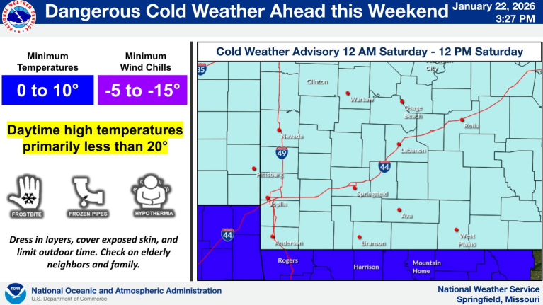
Miller goes on to say that colder temperatures and bitter wind chills will also combine to make the event particularly dangerous in the lake area…as wind chills could go as low as -15 degrees.
Here’s the latest info from the National Weather Service:
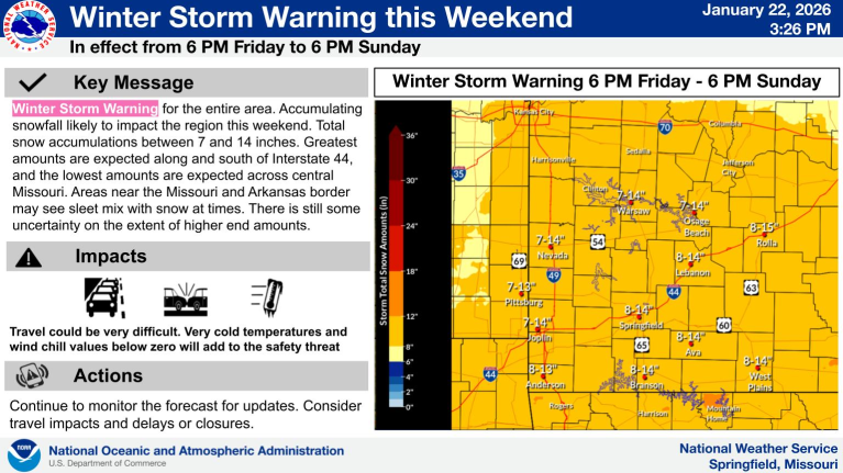
…WINTER STORM WARNING IN EFFECT FROM 6 PM FRIDAY TO 6 PM CST SUNDAY…
* WHAT…Heavy snow expected. Total snow accumulations between 6 and 12 inches. Greatest amounts are expected along and south of Interstate 44 and the lowest amounts are expected across central Missouri. Areas near the Missouri and Arkansas border may see sleet mix with snow at times.
* WHERE…Portions of southeast Kansas and central, east central, south central, southwest, and west central Missouri.
* WHEN…From 6 PM Friday to 6 PM CST Sunday.
* IMPACTS…Travel could be very difficult. Very cold temperatures in the single digits with wind chill values below zero will add to
the safety threat. Motorists should avoid traveling but will need to plan for cold weather survival in the event they become stranded.
PRECAUTIONARY/PREPAREDNESS ACTIONS…
If you must travel, keep an extra flashlight, food, and water in your vehicle in case of an emergency. In Missouri, call 1-888-275-6636 for road conditions.
ALSO
…EXTREME COLD WARNING IN EFFECT FROM MIDNIGHT FRIDAY NIGHT TO NOON CST MONDAY…
* WHAT…Dangerously cold wind chills of 5 below to colder than 15 below zero expected.
* WHERE…Portions of central, eastern, north central, southeast, southwest, and western Arkansas.
* WHEN…From midnight Friday Night to noon CST Monday.
* IMPACTS…The cold wind chills as low as 5 to colder than 15 below zero could result in hypothermia or frostbite if precautions are
not taken. Frostbite and hypothermia will occur if unprotected skin is exposed to these temperatures. An extended period of freezing temperatures could cause ruptured water pipes.
PRECAUTIONARY/PREPAREDNESS ACTIONS…
Dress in layers including a hat, face mask, and gloves if you must go outside. To prevent water pipes from freezing; wrap or drain or allow them to drip slowly.
Make sure outdoor animals have a warm, dry shelter, food, and unfrozen water.
Make frequent checks on older family, friends, and neighbors. Ensure portable heaters are used correctly. Do not use generators or grills inside.

Reporter John Rogger