Flood Advisories And Flood Warnings Are In Effect
A number of Flood Advisories and Flood warnings are in effect for the Lake Region….

…FLOOD ADVISORY NOW IN EFFECT UNTIL 1 PM CDT THIS AFTERNOON…
* WHAT…Flooding caused by excessive rainfall continues.
* WHERE…Portions of central, east central, and southwest Missouri, including the following counties, in central Missouri, Camden,
Maries, Miller and Pulaski. In east central Missouri, Phelps. In southwest Missouri, Dallas and Laclede.
* WHEN…Until 100 PM CDT Thursday.
* IMPACTS…Minor flooding in low-lying and poor drainage areas.
* ADDITIONAL DETAILS…
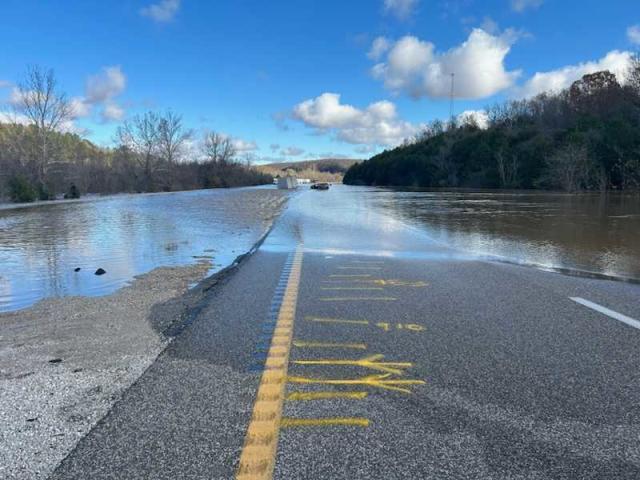
– At 432 AM CDT, The Department of Transportation reported flooding from previous heavy rain in the advisory area. Between 1 and 3 inches of rain have fallen.
– This includes the following low water crossings…
Dry Fork at County Road 407, Mountain Creek at Kinfolk Road, Wet Glaize at Carrol Cave Road, Weimer Creek at White School
Road, Dry Auglaize Creek at Freedom Ridge Road, Maries River at County Road 211 and Dry Auglaize Creek at Highway BB.
Flooding impacts will continue, but no additional rainfall is expected.
– Some locations that will experience flooding include… Rolla, northern Fort Leonard Wood, Lebanon, Waynesville, Buffalo, St. Robert, St. James, Richland, Dixon, Belle, Crocker, Iberia, Doolittle, Vienna, Newburg, Stoutland, Bennett Springs, Brumley, Swedeborg, Ozark Springs, Laquey, Wet Glaize, Montreal, Freedom, Devil`s Elbow, Sleeper, Brinktown, Jerome, Decaturville, Eldridge, Northwye, Vichy, Windyville, Long Lane, Plad, Charity, Rosati, March, Foose and Lake of The Ozarks.
PRECAUTIONARY/PREPAREDNESS ACTIONS…
Turn around, don`t drown when encountering flooded roads. Many flood deaths occur in vehicles.
Please report observed flooding to local emergency services or law enforcement and request they pass this information to the National
Weather Service when you can do so safely.
-o-
…FLOOD WARNING IN EFFECT UNTIL 1 PM CDT THIS AFTERNOON…
* WHAT…Flooding from heavy rainfall that occurred across the area Wednesday evening will continue overnight into Thursday morning.
* WHERE…Portions of central and southwest Missouri, including the following counties, in central Missouri, Camden and Hickory. In southwest Missouri, Dallas.
* WHEN…Until 100 PM CDT Thursday.
* IMPACTS…Flooding of rivers, creeks, streams, and other low-lying and flood-prone locations is imminent or occurring. Low-water
crossings are inundated with water and may not be passable.
* ADDITIONAL DETAILS…
– At 1216 AM CDT, The Department of Transportation reported flooding from previous heavy rain in the warned area. Between
2 and 4 inches of rain have fallen. – This includes the following low water crossings… Cahoochie Creek at Highway BB, Lindley Creek at Mathis Road, Starks Creek at Highway P, Macks Creek at Coffey Hollow Road, Little Niangua at County Road 200, Little Niangua at County Road 66 and Little Niangua River at Highway E.
– Some locations that will experience flooding include…
Buffalo, Urbana, Macks Creek, Louisburg, Tunas, Branch, Leadmine, Pumpkin Center and Plad.
-o-
…FLOOD WARNING IN EFFECT UNTIL 1 PM CDT THURSDAY…
* WHAT…Flooding from heavy rainfall that occurred across the area Wednesday evening will continue overnight into Thursday morning.
* WHERE…Portions of southeast Kansas, including the following county, Cherokee and Missouri, including the following counties,
Barton, Cedar, Dade, Hickory, Jasper and Polk. * WHEN…Until 100 PM CDT Thursday.
* IMPACTS…Flooding of rivers, creeks, streams, and other low-lying and flood-prone locations is imminent or occurring.
* ADDITIONAL DETAILS…
– At 1137 PM CDT, The Department of Transportation reported flooding from previous heavy rain in the warned area. Between
2 and 4 inches of rain have fallen.
– This includes the following low water crossings…
Dry Fork at Pine Road, Turkey Creek at Highway W, Bear Creek at 60th Road, Sinking Creek at County Road 181, Slagle Creek
at 86 Road, Sons Creek at County Road 113 and Weaubleau Creek at Highway V.
– Some locations that will experience flooding include… Northern Joplin, Carthage, Bolivar, Lamar, Baxter Springs, Columbus, Stockton, Greenfield, Webb City, Carl Junction, Galena, Oronogo, Carterville, Lockwood, Jasper, Golden City, Weir, Alba, Scammon, Fair Play, Purcell, Morrisville, West Mineral, Treece, Pittsburg, Airport Drive, Lowell, Polk, Nashville, Carytown, Dadeville, Jerico Springs, Asbury, Neck City, Lamar Heights, Halfway, Brooklyn Heights, South Greenfield, Waco and Aldrich.

Reporter John Rogger