SEVERE WEATHER WARNINGS & WATCHES ON KRMSRADIO.COM
All News RSS Feed Saturday, April 27th, 2024
Latest Warnings:
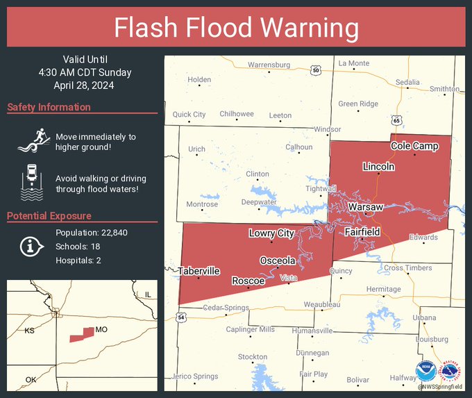
Flash Flood Warning including Warsaw MO, Lincoln MO and Appleton City MO until 4:30 AM CDT
The National Weather Service in Springfield has issued a

* Flash Flood Warning for...
  Benton County in central Missouri...
  St. Clair County in west central Missouri...

* Until 430 AM CDT.

* At 1032 PM CDT, Doppler radar indicated thunderstorms producing
  heavy rain across the warned area. Up to 2 inches of rain have
  fallen. Additional rainfall amounts of 2 to 4 inches are possible
  in the warned area. Flash flooding is ongoing or expected to begin
  shortly.

  HAZARD...Flash flooding caused by thunderstorms.

  SOURCE...Radar.

  IMPACT...Flash flooding of small creeks and streams, urban
           areas, highways, streets and underpasses as well as
           other poor drainage and low-lying areas.

* Some locations that will experience flash flooding include...
  Warsaw, Lincoln, Appleton City, Cole Camp, Osceola, Lowry City,
  Roscoe, Vista, Racket, Iconium, Whitakerville, Harper, Palo Pinto,
  Brandon, Edmonson, Hastain, Lakeview Heights, Monegaw Springs,
  Johnson City, Zora, Mora, Crockerville, Tiffin, Taberville, Truman
  Lake, Lake of The Ozarks and Truman State Park.

This includes the following streams and drainages...
  Marshall Creek, Osage River, Otten Branch, Flat Rock Creek, Brush
  Creek, Lemon Branch, Camp Branch, Monegaw Creek, Deer Creek, Duran
  Creek, Turkey Creek, Campbell Branch, Pomme De Terre Lake,
  Weaubleau Creek, Haw Creek, Finley Creek, Little Clear Creek,
  Flemming Branch, P D Creek, Cole Camp Creek, Sac River, Williams
  Creek, Bird Branch, Hogles Creek, Little Turkey Creek, Salt Creek,
  Bauer Branch, Gallinipper Creek, Ditty Creek, South Fork Blue
  Branch, Clear Creek, Kitten Creek, Yellow Creek, Simms Creek, Duck
  Creek, South Flat Creek, Indian Creek, Carman Creek, Coon Creek,
  Little Tebo Creek, Panther Creek, Little Monegaw Creek, Ricky
  Creek, Lake Creek, Reid Creek, Spill Creek and Ross Creek.

PRECAUTIONARY/PREPAREDNESS ACTIONS...

Turn around, don`t drown when encountering flooded roads. Many flood
deaths occur in vehicles.

Be especially cautious at night when it is harder to recognize the
dangers of flooding.
Current Watches:
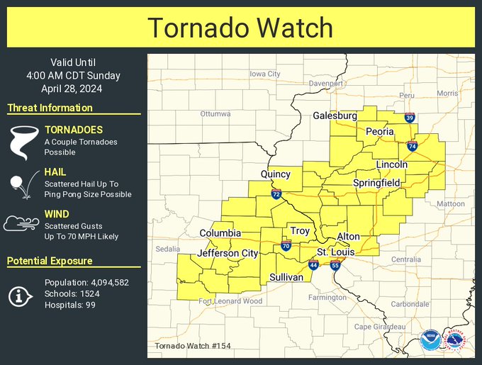
A tornado watch has been issued for parts of Illinois and Missouri until 4 AM CDT
MOC007-019-027-029-051-071-073-113-125-127-131-135-137-139-141-
151-163-173-183-189-219-510-280900-
/O.NEW.KWNS.TO.A.0154.240428T0240Z-240428T0900Z/

MO
.    MISSOURI COUNTIES INCLUDED ARE

AUDRAIN              BOONE               CALLAWAY
CAMDEN               COLE                FRANKLIN
GASCONADE            LINCOLN             MARIES
MARION               MILLER              MONITEAU
MONROE               MONTGOMERY          MORGAN
OSAGE                PIKE                RALLS
ST. CHARLES          ST. LOUIS           WARREN
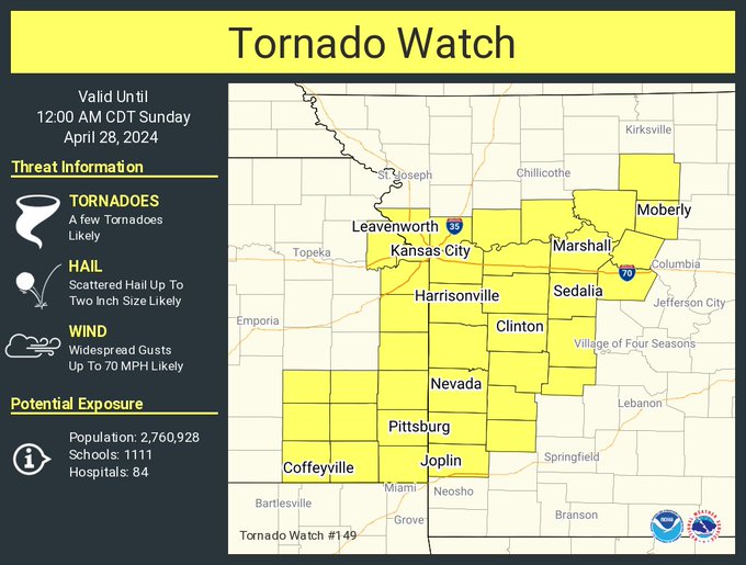
TORNADO WATCH 149 REMAINS VALID UNTIL MIDNIGHT CDT TONIGHT FOR
THE FOLLOWING AREAS

IN KANSAS THIS WATCH INCLUDES 3 COUNTIES

IN SOUTHEAST KANSAS

BOURBON               CHEROKEE              CRAWFORD

IN MISSOURI THIS WATCH INCLUDES 8 COUNTIES

IN CENTRAL MISSOURI

BENTON                HICKORY

IN SOUTHWEST MISSOURI

BARTON                CEDAR                 DADE
JASPER

IN WEST CENTRAL MISSOURI

ST. CLAIR             VERNON

THIS INCLUDES THE CITIES OF APPLETON CITY, ARNICA,
BAXTER SPRINGS, CAPLINGER MILLS, CARTHAGE, CEDAR SPRINGS,
CHICOPEE, COLE CAMP, COLUMBUS, CROCKERVILLE, CROSS TIMBERS,
EDMONSON, EL DORADO SPRINGS, FILLEY, FORT SCOTT, GREENFIELD,
HERMITAGE, JOHNSON CITY, JOPLIN, KENOMA, LAMAR, LINCOLN,
LOCKWOOD, LONE OAK, LOWELL, MEINERT, MORA, NEUTRAL, NEVADA,
PAWNEE STATION, PITTSBURG, PITTSBURG, QUINCY, RIVERTON, SHERWIN,
STIPPVILLE, STOCKTON, TIFFIN, WARSAW, WEAUBLEAU, WHEATLAND,
AND WHITAKERVILLE.
All News RSS Feed Saturday, April 27th, 2024

Reporter John Rogger