Active Weather Alerts And Storm Updates In The Lake Area
Strong Storms rolled into the Lake Area around 3AM this morning, causing power outages in the community.
Numerous severe alerts were issued as the line made it’s way across the Lake, including a Tornado Warning that affected areas of Camden County.
Forecasters saw what appeared to be a radar indicated Tornado Signature near Macks Creek.
It’s unknown if that system spawned a Tornado at this time.
Listeners have reported damage across the Lake, including a roof ripped off a home in Brumley, windows damaged in Eldon, and debris scattered in front of Stewarts Restaurant on the Bagnell Dam Strip.
The storms did bring heavy rains, high winds and there were actively changing conditions….below are the latest watches/warnings/updates for our community.
CURRENT:
...WIND ADVISORY REMAINS IN EFFECT UNTIL NOON CST TODAY...

* WHAT...South winds 20 to 30 mph with gusts up to 50 mph
  expected.

* WHERE...Portions of southeast Kansas and central, south
  central, southwest and west central Missouri.

* WHEN...Will continue until noon CST Monday.

* IMPACTS...Gusty winds could blow around unsecured objects.
  Tree limbs could be blown down and a few power outages may
  result.

PRECAUTIONARY/PREPAREDNESS ACTIONS...

Use extra caution when driving, especially if operating a high
profile vehicle. Secure outdoor objects.
–
EXPIRED ALERTS:
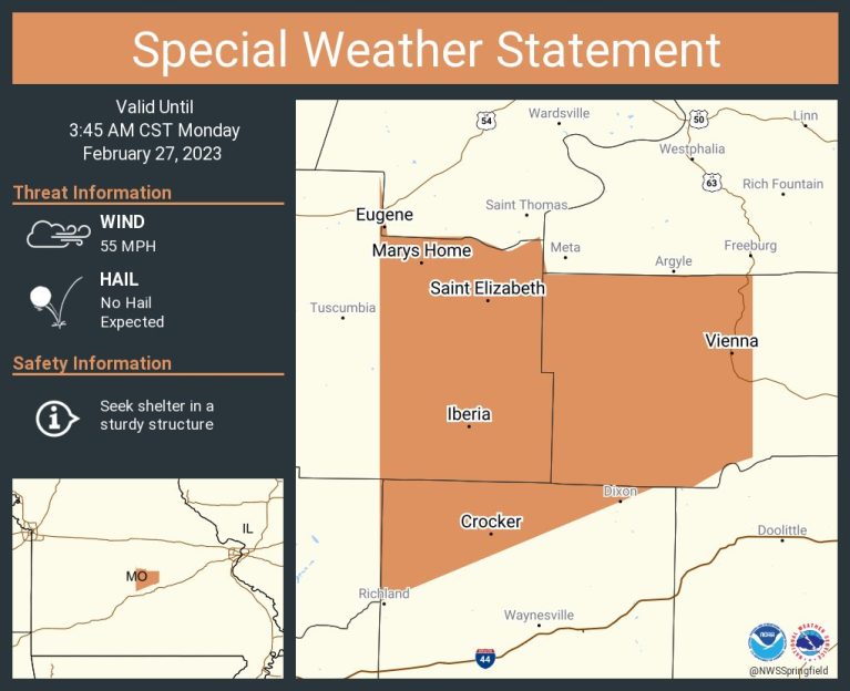
...Strong thunderstorms will impact portions of Maries, northwestern
Dent, eastern Pulaski, north central Texas and Phelps Counties
through 415 AM CST...

At 341 AM CST, Doppler radar was tracking strong thunderstorms along
a line extending from 6 miles east of St. Thomas to 6 miles southeast
of Dixon to 11 miles west of Licking. Movement was northeast at 55
mph.

HAZARD...Wind gusts up to 50 mph.

SOURCE...Radar indicated.

IMPACT...Gusty winds could knock down tree limbs and blow around
         unsecured objects.

Locations impacted include...
Rolla, eastern Fort Leonard Wood, St. James, Belle, Doolittle,
Vienna, Newburg, Edgar Springs, Brinktown, Lenox, Beulah, Devil`s
Elbow, Vichy, Lake Spring, Anutt, Bangert, Howes, Northwye, Lecoma
and Jerome.

This includes Interstate 44 between mile markers 166 and 169, and
between mile markers 171 and 200.

PRECAUTIONARY/PREPAREDNESS ACTIONS...

If outdoors, consider seeking shelter inside a building.


-
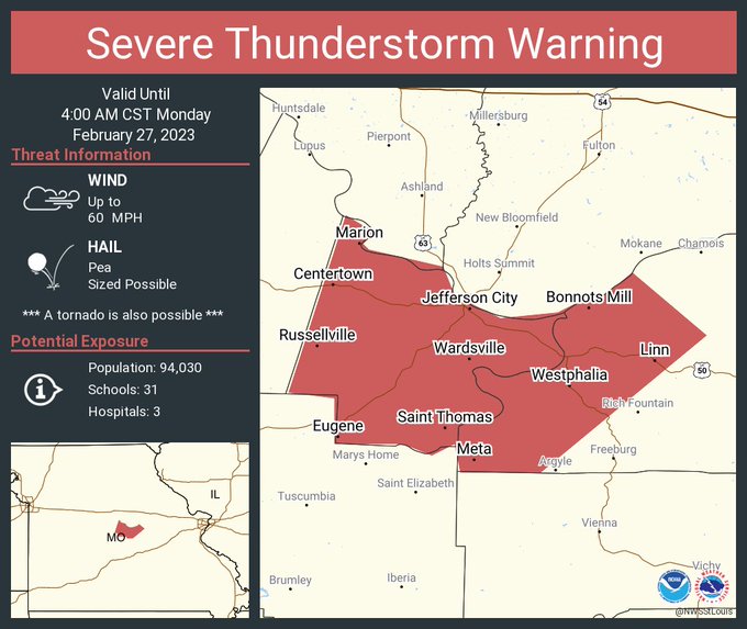
The National Weather Service in St Louis has issued a

* Severe Thunderstorm Warning for...
  Cole County in central Missouri...
  Central Osage County in central Missouri...

* Until 400 AM CST.

* At 311 AM CST, a severe thunderstorm was located 7 miles southeast
  of Eldon, moving northeast at 60 mph.

  HAZARD...60 mph wind gusts.

  SOURCE...Radar indicated.

  IMPACT...Expect damage to roofs, siding, and trees.

* This severe thunderstorm will be near...
  Hickory Hill around 320 AM CST.
  St. Thomas and Brazito around 325 AM CST.
  Wardsville around 330 AM CST.

Other locations in the path of this severe thunderstorm include Taos
and Westphalia.

This also includes Clarks Hill/Norton Historic Site and Jefferson
Landing Historic Site.

PRECAUTIONARY/PREPAREDNESS ACTIONS...

For your protection move to an interior room on the lowest floor of a
building.
–
...Strong thunderstorms will impact portions of western Maries,
eastern Miller and northwestern Pulaski Counties through 345 AM
CST...

At 311 AM CST, Doppler radar was tracking strong thunderstorms along
a line extending from near Eldon to 7 miles east of Osage Beach to 6
miles southwest of Richland. Movement was northeast at 60 mph.

HAZARD...Wind gusts of 50 to 55 mph.

SOURCE...Radar indicated.

IMPACT...Gusty winds could knock down tree limbs and blow around
         unsecured objects.

Locations impacted include...
Richland, Dixon, Crocker, Iberia, Vienna, Saint Elizabeth, St.
Elizabeth, Brinktown, Swedeborg and Marys Home.

PRECAUTIONARY/PREPAREDNESS ACTIONS...

If outdoors, consider seeking shelter inside a building.
–
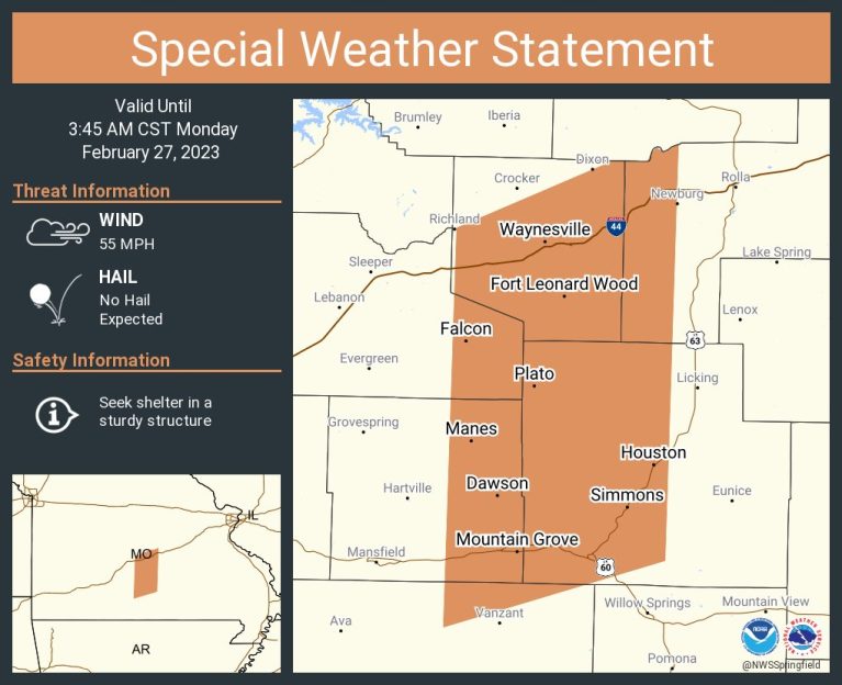
...Strong thunderstorms will impact portions of eastern Wright, north
central Douglas, southeastern Laclede, Pulaski, western Texas and
western Phelps Counties through 345 AM CST...

At 309 AM CST, Doppler radar was tracking strong thunderstorms along
a line extending from 7 miles southwest of Richland to 8 miles north
of Hartville to 6 miles southeast of Ava. Movement was northeast at
60 mph.

HAZARD...Wind gusts of 50 to 55 mph.

SOURCE...Radar indicated.

IMPACT...Gusty winds could knock down tree limbs and blow around
         unsecured objects.

Locations impacted include...
Fort Leonard Wood, Waynesville, Mountain Grove, St. Robert, Cabool,
Houston, Richland, Dixon, Dawson, Norwood, Doolittle, Newburg,
Huggins, Plato, Manes, Beulah, Lynchburg, Falcon, Success and Laquey.

This includes Interstate 44 between mile markers 145 and 169, and
between mile markers 171 and 177.

PRECAUTIONARY/PREPAREDNESS ACTIONS...

If outdoors, consider seeking shelter inside a building.

&&

LAT...LON 3786 9240 3801 9205 3801 9197 3803 9196
      3804 9195 3803 9193 3805 9190 3711 9193
      3696 9243
TIME...MOT...LOC 0909Z 230DEG 53KT 3779 9250 3737 9247 3688 9258

MAX HAIL SIZE...0.00 IN
MAX WIND GUST...55 MPH
–
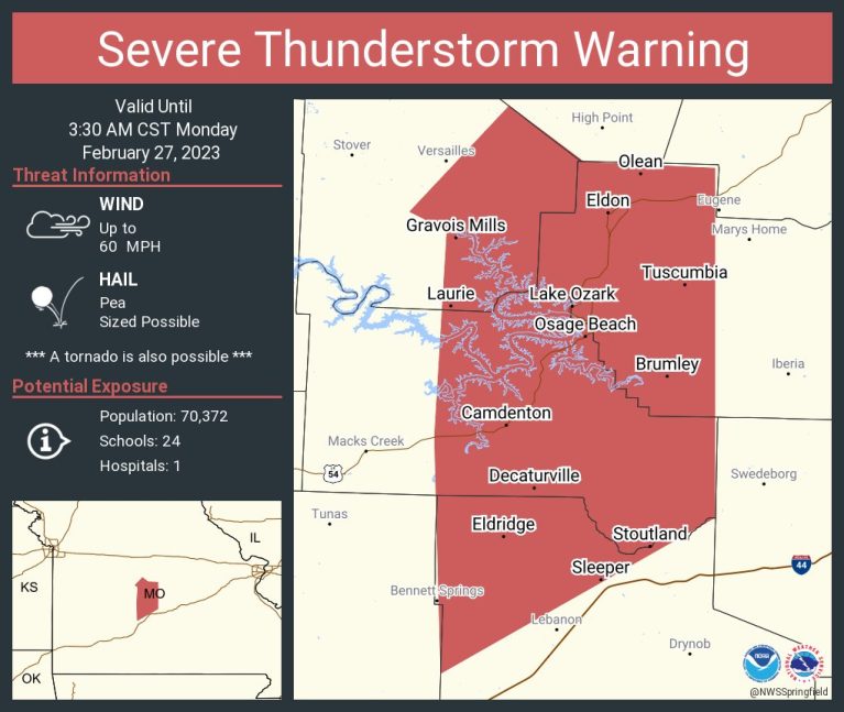
The National Weather Service in Springfield has issued a

* Severe Thunderstorm Warning for...
  Western Miller County in central Missouri...
  Northwestern Laclede County in southwestern Missouri...
  Camden County in central Missouri...
  Southeastern Morgan County in central Missouri...

* Until 330 AM CST.

* At 245 AM CST, severe thunderstorms were located along a line
  extending from 11 miles west of Laurie to near Macks Creek to 13
  miles east of Urbana, moving northeast at 60 mph.

  HAZARD...60 mph wind gusts.

  SOURCE...Radar indicated.

  IMPACT...Expect damage to roofs, siding, and trees.

* Locations impacted include...
  Lebanon, Lake of The Ozarks, Lake of The Ozarks State Park, Ha Ha
  Tonka State Park, Bennett Spring State Park, Eldon, Osage Beach,
  Camdenton, Village of Four Seasons, Richland, Lake Ozark, Laurie,
  Sunrise Beach, Linn Creek, Tuscumbia, Barnett, Stoutland, Gravois
  Mills, Olean and Bagnell.

PRECAUTIONARY/PREPAREDNESS ACTIONS...

For your protection move to an interior room on the lowest floor of a
building.
–
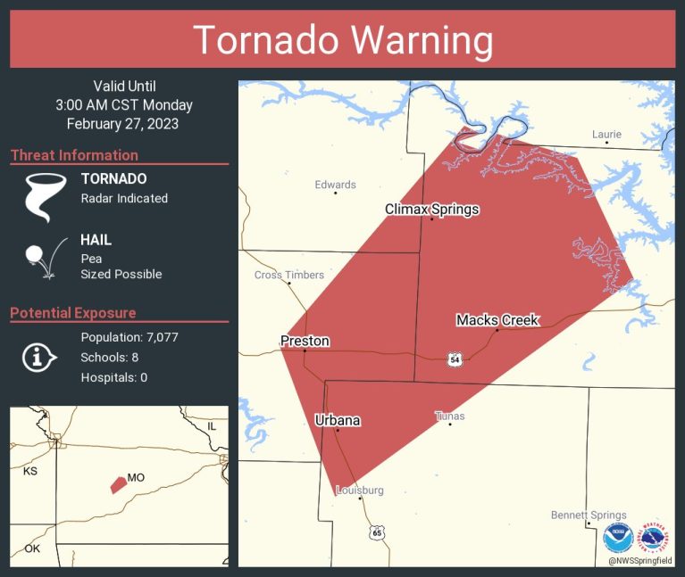
Tornado Warning including Urbana MO, Macks Creek MO and Preston MO until 3:00 AM CST
The National Weather Service in Springfield has issued a

* Tornado Warning for...
  Eastern Hickory County in central Missouri...
  Northwestern Dallas County in southwestern Missouri...
  Northwestern Camden County in central Missouri...

* Until 300 AM CST.

* At 226 AM CST, severe thunderstorms capable of producing a tornado
  were located along a line extending from 7 miles east of Hermitage
  to near Urbana to 10 miles north of Buffalo, moving northeast at 65
  mph.

  HAZARD...Tornado.

  SOURCE...Radar indicated rotation.

  IMPACT...Flying debris will be dangerous to those caught without
           shelter. Mobile homes will be damaged or destroyed.
           Damage to roofs, windows, and vehicles will occur.  Tree
           damage is likely.

* Locations impacted include...
  Lake of The Ozarks, Urbana, Macks Creek, Preston, Climax Springs,
  Branch and Barnumton.

PRECAUTIONARY/PREPAREDNESS ACTIONS...

TAKE COVER NOW! Move to a basement or an interior room on the lowest
floor of a sturdy building. Avoid windows. If you are outdoors, in a
mobile home, or in a vehicle, move to the closest substantial shelter
and protect yourself from flying debris.
–
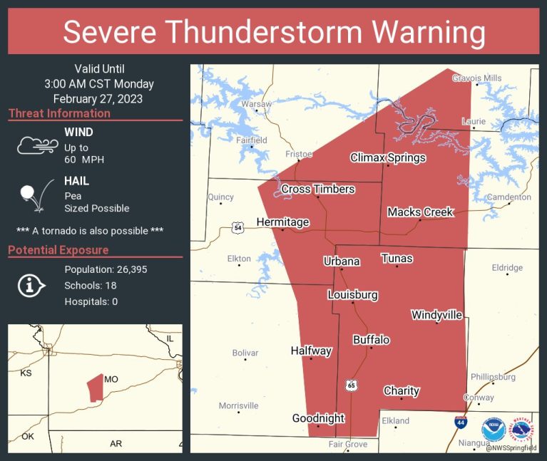
The National Weather Service in Springfield has issued a * Severe Thunderstorm Warning for... Eastern Hickory County in central Missouri... Dallas County in southwestern Missouri... Southeastern Benton County in central Missouri... Eastern Polk County in southwestern Missouri... Western Camden County in central Missouri... Southwestern Morgan County in central Missouri... * Until 300 AM CST. * At 221 AM CST, severe thunderstorms were located along a line extending from near Hermitage to near Urbana to near Pleasant Hope, moving northeast at 65 mph. HAZARD...60 mph wind gusts. SOURCE...Radar indicated. IMPACT...Expect damage to roofs, siding, and trees. * Locations impacted include... Pomme de Terre Lake, Lake of The Ozarks, Pomme De Terre State Park, Bennett Spring State Park, Buffalo, Pittsburg, Laurie, Conway, Hermitage, Urbana, Macks Creek, Preston, Cross Timbers, Halfway, Bennett Springs, Climax Springs, Louisburg, Windyville, March and Tunas. PRECAUTIONARY/PREPAREDNESS ACTIONS... For your protection move to an interior room on the lowest floor of a building. -The National Weather Service in Springfield has issued a * Severe Thunderstorm Warning for... Northwestern Hickory County in central Missouri... Benton County in central Missouri... * Until 300 AM CST. * At 209 AM CST, severe thunderstorms were located along a line extending from 10 miles east of Deepwater to 9 miles east of Lowry City to near Weaubleau, moving northeast at 55 mph. HAZARD...60 mph wind gusts. SOURCE...Radar indicated. IMPACT...Expect damage to roofs, siding, and trees. * Locations impacted include... Truman Lake, Truman State Park, Warsaw, Lincoln, Cole Camp, Ionia, Palo Pinto, Quincy, Lakeview Heights, Crockerville, Zora, Fristoe, Racket, Edmonson, Mora, Hastain and Whitakerville. PRECAUTIONARY/PREPAREDNESS ACTIONS... For your protection move to an interior room on the lowest floor of a building.

Reporter John Rogger