NO Active Weather Warnings In The Lake Area At This Time
Severe Weather Wednesday, April 5th, 2023
Active weather rolled through the Lake Region early this morning into the mid-morning hours, but has since passed. Here’s a look at the storms as they came in and what watches/warnings were issued:
PAST WATCHES:
SEVERE THUNDERSTORM WATCH 122 REMAINS VALID UNTIL 10 AM CDT THIS
MORNING FOR THE FOLLOWING AREAS

IN MISSOURI THIS WATCH INCLUDES 8 COUNTIES

IN CENTRAL MISSOURI

MARIES                PULASKI

IN EAST CENTRAL MISSOURI

PHELPS

IN SOUTH CENTRAL MISSOURI

DENT                  TEXAS

IN SOUTHWEST MISSOURI

DOUGLAS               TANEY                 WRIGHT

-o-

SEVERE THUNDERSTORM WATCH 122 REMAINS VALID UNTIL 10 AM CDT THIS
MORNING FOR THE FOLLOWING AREAS

IN MISSOURI THIS WATCH INCLUDES 26 COUNTIES

IN CENTRAL MISSOURI

CAMDEN                HICKORY               MARIES
MILLER                PULASKI

IN EAST CENTRAL MISSOURI

PHELPS

IN SOUTH CENTRAL MISSOURI

DENT                  TEXAS

IN SOUTHWEST MISSOURI

BARRY                 BARTON                CEDAR
CHRISTIAN             DADE                  DALLAS
DOUGLAS               GREENE                JASPER
LACLEDE               LAWRENCE              MCDONALD
NEWTON                POLK                  STONE
TANEY                 WEBSTER               WRIGHT

THIS INCLUDES THE CITIES OF ANDERSON, ARNICA, AURORA,
AURORA SPRINGS, AVA, BANGERT, BENDAVIS, BOLIVAR, BRANSON,
BUFFALO, CAMDENTON, CAPLINGER MILLS, CARTHAGE, CASSVILLE,
CEDAR SPRINGS, CHARITY, CHRISTIAN CENTER, CRANE, CROSS TIMBERS,
DARIEN, DAWSON, DECATURVILLE, DOGWOOD, DUNCAN, EDGEWATER BEACH,
EL DORADO SPRINGS, ELDON, ELSEY, FILLEY, FOOSE, FORSYTH,
FORT LEONARD WOOD, GLADDEN, GOODHOPE, GOODMAN, GRAFF, GREENFIELD,
HERMITAGE, HOLLISTER, HOWES, HUGGINS, INDIAN POINT, JADWIN,
JOPLIN, KENOMA, KIMBERLING CITY, KIRBYVILLE, LAKE OZARK,
LAKE SPRING, LAMAR, LAQUEY, LEBANON, LOCKWOOD, LYNCHBURG, MADRY,
MANSFIELD, MARCH, MARIONVILLE, MARSHFIELD, MEINERT, MONETT,
MOUNT VERNON, MOUNTAIN GROVE, NEOSHO, NIXA, NOEL, NORTHVIEW,
NORTHWYE, OLIVE, OSAGE BEACH, OZARK, OZARK BEACH, PINEVILLE,
PITTSBURG, PLAD, PLATO, POWERSITE, QUINCY, ROACH, ROBY,
ROCKY COMFORT, ROGERSVILLE, ROLLA, ROME, SALEM, SELMORE, SEYMOUR,
SILVER DOLLAR CITY, SOUTH WEST CITY, SPRINGFIELD, SQUIRES,
STOCKTON, VANZANT, VICHY, VILLAGE OF FOUR SEASONS, WAYNESVILLE,
WEAUBLEAU, WHEATLAND, AND WINDYVILLE.

-o-
PAST WARNINGS:
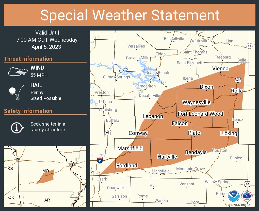
...Strong thunderstorms will impact portions of central Maries,
Webster, Wright, southeastern Miller, Laclede, Pulaski, northern
Texas, southeastern Greene, Phelps and southeastern Camden Counties
through 700 AM CDT...

At 628 AM CDT, Doppler radar was tracking strong thunderstorms along
a line extending from Richland to 6 miles north of Hartville to near
Rogersville. Movement was northeast at 60 mph.

HAZARD...Wind gusts of 50 to 55 mph and penny size hail.

SOURCE...Radar indicated.

IMPACT...Gusty winds could knock down tree limbs and blow around
         unsecured objects. Minor damage to outdoor objects is
         possible.

Locations impacted include...
Rolla, Fort Leonard Wood, Lebanon, Marshfield, Waynesville, St.
Robert, Licking, Rogersville, Richland, Dixon, Belle, Morgan,
Crocker, Fordland, Conway, Iberia, Doolittle, Hartville, Vienna and
Newburg.

This includes Interstate 44 between mile markers 92 and 108, between
mile markers 114 and 169, and between mile markers 171 and 190.

PRECAUTIONARY/PREPAREDNESS ACTIONS...

If outdoors, consider seeking shelter inside a building.

A Severe Thunderstorm Watch remains in effect until 1000 AM CDT for
central, south central, southwestern and east central Missouri.
-o-
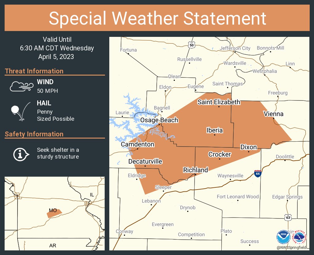
...A strong thunderstorm will impact portions of western Maries,
Miller, north central Laclede, northern Pulaski and eastern Camden
Counties through 630 AM CDT...

At 555 AM CDT, Doppler radar was tracking a strong thunderstorm near
Camdenton, moving northeast at 60 mph.

HAZARD...Wind gusts up to 50 mph and penny size hail.

SOURCE...Radar indicated.

IMPACT...Gusty winds could knock down tree limbs and blow around
         unsecured objects. Minor damage to outdoor objects is
         possible.

Locations impacted include...
Lake of The Ozarks State Park, Ha Ha Tonka State Park, Lake of The
Ozarks, Osage Beach, Camdenton, Richland, Dixon, Crocker, Iberia,
Vienna, St. Elizabeth, Saint Elizabeth, Linn Creek, Tuscumbia,
Stoutland, Brumley, Freedom, Kaiser, Old Linn Creek and Decaturville.

PRECAUTIONARY/PREPAREDNESS ACTIONS...

If outdoors, consider seeking shelter inside a building.

A Severe Thunderstorm Watch remains in effect until 1000 AM CDT for
central, southwestern and east central Missouri.

-o-

The National Weather Service in Springfield has issued a

* Severe Thunderstorm Warning for...
  Webster County in southwestern Missouri...
  Southern Dallas County in southwestern Missouri...
  Wright County in southwestern Missouri...
  Laclede County in southwestern Missouri...
  Southwestern Pulaski County in central Missouri...
  Eastern Greene County in southwestern Missouri...

* Until 630 AM CDT.

* At 552 AM CDT, severe thunderstorms were located along a line
  extending from 8 miles north of Fair Grove to near Strafford to
  near Clever, moving northeast at 65 mph.

  HAZARD...60 mph wind gusts and quarter size hail.

  SOURCE...Radar indicated.

  IMPACT...Hail damage to vehicles is expected. Expect wind damage
           to roofs, siding, and trees.

* Locations impacted include...
  Eastern Springfield, southwestern Fort Leonard Wood, Lebanon,
  Bennett Spring State Park, Marshfield, Waynesville, Rogersville,
  Strafford, Seymour, Richland, Morgan, Fair Grove, Fordland, Conway,
  Dawson, Hartville, Niangua, Duncan, Diggins and Phillipsburg.

 This includes Interstate 44 between mile markers 81 and 154.

PRECAUTIONARY/PREPAREDNESS ACTIONS...

For your protection move to an interior room on the lowest floor of a
building.
-o-
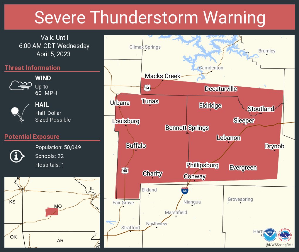
The National Weather Service in Springfield has issued a
* Severe Thunderstorm Warning for…
Dallas County in southwestern Missouri…
Laclede County in southwestern Missouri…
Southern Camden County in central Missouri…
* Until 600 AM CDT.
* At 516 AM CDT, a severe thunderstorm was located 8 miles north of
Pleasant Hope, or 9 miles east of Bolivar, moving east at 65 mph.
HAZARD…60 mph wind gusts and half dollar size hail.
SOURCE…Public. Half Dollar size hail was reported with this
storm.
IMPACT…Hail damage to vehicles is expected. Expect wind damage
to roofs, siding, and trees.
* Locations impacted include…
Lebanon, Bennett Spring State Park, Ha Ha Tonka State Park,
Buffalo, Morgan, Conway, Urbana, Macks Creek, Phillipsburg,
Stoutland, Bennett Springs, Louisburg, Twin Bridges, Windyville,
March, Tunas, Pumpkin Center, Sleeper, Branch and Decaturville.
This includes Interstate 44 between mile markers 111 and 143.
PRECAUTIONARY/PREPAREDNESS ACTIONS…
For your protection move to an interior room on the lowest floor of a building.
-o-
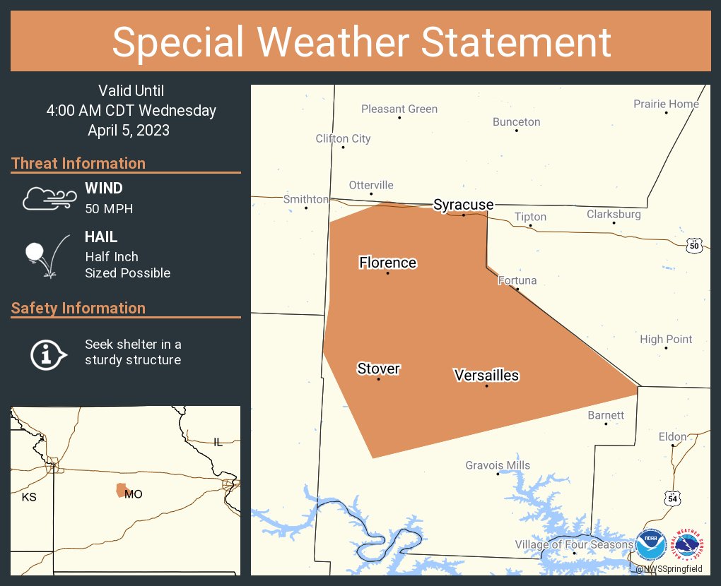
A special weather statement has been issued for Versailles MO, Stover MO and Syracuse MO until 4:00 AM CDT
Severe Weather Wednesday, April 5th, 2023

Reporter John Rogger