ACTIVE WEATHER WARNINGS & INFO AT KRMSRADIO.COM
Severe Weather Friday, March 31st, 2023
Here’s the latest active weather warnings & more for the listening area:
CURRENT WARNINGS:
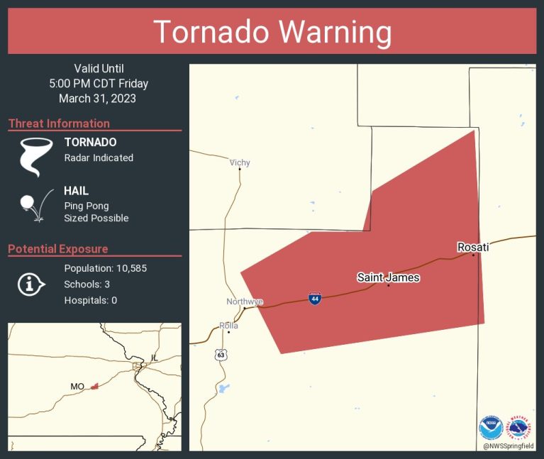
Tornado Warning including Saint James MO and Rosati MO until 5:00 PM CDT
The National Weather Service in Springfield has issued a

* Tornado Warning for...
  Northeastern Phelps County in east central Missouri...

* Until 500 PM CDT.

* At 449 PM CDT, a severe thunderstorm capable of producing a tornado
  was located near St. James moving east at 70 mph.

  HAZARD...Tornado and ping pong ball size hail.

  SOURCE...Radar indicated rotation.

  IMPACT...Flying debris will be dangerous to those caught without
           shelter. Mobile homes will be damaged or destroyed.
           Damage to roofs, windows, and vehicles will occur.  Tree
           damage is likely.

* Locations impacted include...
  St. James and Rosati.

This includes Interstate 44 between mile markers 189 and 200.
PAST WARNINGS:
...A strong thunderstorm will impact portions of northwestern Maries,
central Miller and northeastern Camden Counties through 500 PM CDT...

At 424 PM CDT, Doppler radar was tracking a strong thunderstorm over
Osage Beach, moving northeast at 65 mph.

HAZARD...Wind gusts up to 50 mph and penny size hail.

SOURCE...Radar indicated.

IMPACT...Gusty winds could knock down tree limbs and blow around
         unsecured objects. Minor damage to outdoor objects is
         possible.

Locations impacted include...
Lake of The Ozarks State Park, Lake of The Ozarks, Osage Beach, Lake
Ozark, Saint Elizabeth, St. Elizabeth, Linn Creek, Tuscumbia, Ulman,
Marys Home and Kaiser.
-o-
...A strong thunderstorm will impact portions of east central Pulaski
and northwestern Phelps Counties through 445 PM CDT...

At 416 PM CDT, Doppler radar was tracking a strong thunderstorm over
northern Fort Leonard Wood, moving northeast at 60 mph.

HAZARD...Wind gusts up to 50 mph and nickel size hail.

SOURCE...Radar indicated.

IMPACT...Gusty winds could knock down tree limbs and blow around
         unsecured objects. Minor damage to outdoor objects is
         possible.

Locations impacted include...
Rolla, northern Fort Leonard Wood, Waynesville, St. Robert,
Doolittle, Newburg, Northwye, Devil`s Elbow and Jerome.

This includes Interstate 44 between mile markers 155 and 169, and
between mile markers 171 and 188.

-o-
The National Weather Service in Springfield has issued a

* Severe Thunderstorm Warning for...
  Northeastern Webster County in southwestern Missouri...
  Northern Wright County in southwestern Missouri...
  Southern Laclede County in southwestern Missouri...

* Until 430 PM CDT.

* At 338 PM CDT, a severe thunderstorm was located over Marshfield,
  moving northeast at 70 mph.

  HAZARD...60 mph wind gusts and quarter size hail.

  SOURCE...Radar indicated.

  IMPACT...Hail damage to vehicles is expected. Expect wind damage
           to roofs, siding, and trees.

* Locations impacted include...
  Marshfield, Morgan, Conway, Niangua, Twin Bridges, Competition,
  Rader, Lynchburg, Grovespring, Dry Knob and Falcon.

 This includes Interstate 44 between mile markers 99 and 108, near
mile marker 120, and between mile markers 142 and 144.
-o-
...A strong thunderstorm will impact portions of northeastern Benton
and northern Morgan Counties through 345 PM CDT...

At 311 PM CDT, Doppler radar was tracking a strong thunderstorm near
Lincoln, or 11 miles northeast of Warsaw, moving northeast at 65 mph.

HAZARD...Wind gusts up to 50 mph and penny size hail.

SOURCE...Radar indicated.

IMPACT...Gusty winds could knock down tree limbs and blow around
         unsecured objects. Minor damage to outdoor objects is
         possible.

Locations impacted include...
Versailles, Lincoln, Cole Camp, Stover, Syracuse, Edmonson, Florence
and Crockerville.

-o-
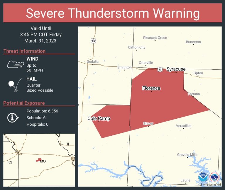
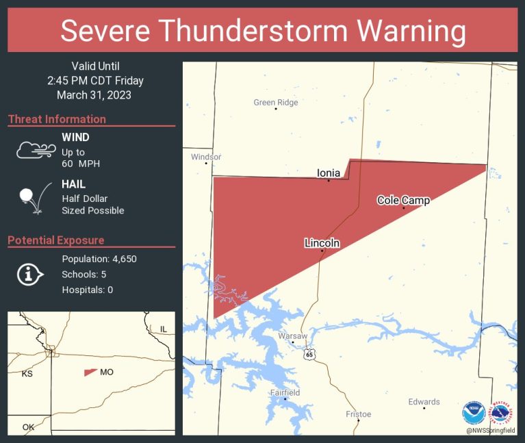
The National Weather Service in Springfield has issued a

* Severe Thunderstorm Warning for...
  Northeastern Benton County in central Missouri...
  Northern Morgan County in central Missouri...

* Until 345 PM CDT.

* At 318 PM CDT, a severe thunderstorm was located near Cole Camp, or
  14 miles west of Versailles, moving northeast at 75 mph.

  HAZARD...60 mph wind gusts and quarter size hail.

  SOURCE...Radar indicated.

  IMPACT...Hail damage to vehicles is expected. Expect wind damage
           to roofs, siding, and trees.

* Locations impacted include...
  Cole Camp, Stover, Syracuse, Crockerville and Florence.

PRECAUTIONARY/PREPAREDNESS ACTIONS...

A Tornado Watch remains in effect until 800 PM CDT for central
Missouri.

For your protection move to an interior room on the lowest floor of a
building.

A Tornado Watch remains in effect until 800 PM CDT for central
Missouri.

-o-
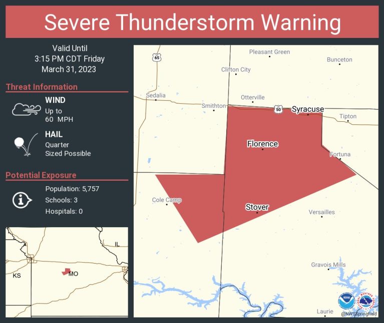
The National Weather Service in Springfield has issued a
* Severe Thunderstorm Warning for...
Northeastern Benton County in central Missouri...
Northwestern Morgan County in central Missouri...
* Until 315 PM CDT.
* At 239 PM CDT, a severe thunderstorm was located near Cole Camp,
or 15 miles west of Versailles, moving northeast at 55 mph. A
second storm was moving across far northern Morgan County.
HAZARD...60 mph wind gusts and quarter size hail.
SOURCE...Radar indicated.
IMPACT...Hail damage to vehicles is expected. Expect wind damage
to roofs, siding, and trees.
* Locations impacted include...
Stover, Syracuse, Crockerville, Mora and Florence.
PRECAUTIONARY/PREPAREDNESS ACTIONS...
A Tornado Watch remains in effect until 800 PM CDT for central
Missouri.
For your protection move to an interior room on the lowest floor of a
building.
A Tornado Watch remains in effect until 800 PM CDT for central
Missouri.
-o-
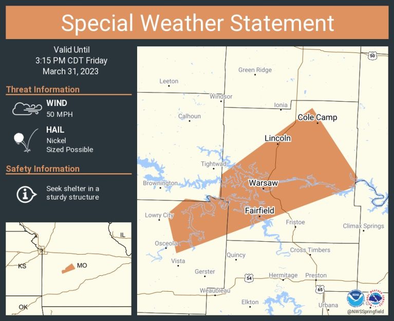 A special weather statement has been issued for Warsaw MO, Lincoln MO and Cole Camp MO until 3:15 PM CDT
...A strong thunderstorm will impact portions of central Benton and
northeastern St. Clair Counties through 315 PM CDT...
At 247 PM CDT, Doppler radar was tracking a strong thunderstorm near
Lowry City, or 16 miles southwest of Warsaw, moving northeast at 55
mph.
HAZARD...Wind gusts up to 50 mph and nickel size hail.
SOURCE...Radar indicated.
IMPACT...Gusty winds could knock down tree limbs and blow around
unsecured objects. Minor damage to outdoor objects is
possible.
Locations impacted include...
Truman State Park, Truman Lake, Warsaw, Lincoln, Cole Camp, Racket,
Edmonson, Lakeview Heights, Zora, Iconium and Whitakerville.
PRECAUTIONARY/PREPAREDNESS ACTIONS...
If outdoors, consider seeking shelter inside a building.
This storm may intensify, so be certain to monitor local radio
stations and available television stations for additional information
and possible warnings from the National Weather Service.
-o-
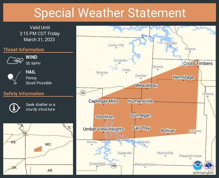 A special weather statement has been issued for Bolivar MO, Stockton MO and Humansville MO until 3:15 PM CDT
...A strong thunderstorm will impact portions of central Hickory,
eastern Cedar, northern Polk and southeastern St. Clair Counties
through 315 PM CDT...

At 228 PM CDT, Doppler radar was tracking a strong thunderstorm over
Stockton, moving northeast at 55 mph.

HAZARD...Wind gusts up to 50 mph and penny size hail.

SOURCE...Radar indicated.

IMPACT...Gusty winds could knock down tree limbs and blow around
         unsecured objects. Minor damage to outdoor objects is
         possible.

Locations impacted include...
Bolivar, Stockton Lake, Pomme de Terre Lake, Pomme De Terre State
Park, Stockton State Park, Stockton, Pittsburg, Humansville, Polk,
Fair Play, Hermitage, Weaubleau, Wheatland, Cross Timbers, Halfway,
Collins, Flemington, Umber View Heights, Bearcreek and Cane Hill.


-o-
The National Weather Service in Springfield has issued a
* Severe Thunderstorm Warning for...
Central Benton County in central Missouri...
* Until 245 PM CDT.
* At 218 PM CDT, a severe thunderstorm was located 8 miles west of
Warsaw, moving northeast at 55 mph.
HAZARD...60 mph wind gusts and quarter size hail.
SOURCE...Radar indicated.
IMPACT...Hail damage to vehicles is expected. Expect wind damage
to roofs, siding, and trees.
* Locations impacted include...
Truman Lake, Truman State Park, Warsaw, Lincoln, Cole Camp, Racket,
Edmonson and Crockerville.
-o-
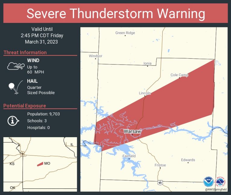
 The National Weather Service in Springfield has issued a * Severe Thunderstorm Warning for... Northern Benton County in central Missouri... * Until 245 PM CDT. * At 159 PM CDT, a severe thunderstorm was located near Clinton, moving northeast at 55 mph. HAZARD...60 mph wind gusts and half dollar size hail. SOURCE...Radar indicated. IMPACT...Hail damage to vehicles is expected. Expect wind damage to roofs, siding, and trees. * Locations impacted include... Truman Lake, Lincoln, Cole Camp, Ionia, Palo Pinto, Racket, Mora and Brandon.
Severe Weather Friday, March 31st, 2023

Reporter John Rogger