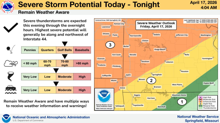
Severe Weather Expected Today With Strong Tornadoes Possible
Here we go again…the lake area is put on notice for the possibility of some more severe weather today.
Cara Foster, with Weatherology, says it’s going to be a pretty active day.
“We are looking at a marginal to enhanced risk throughout the state. I would wager that there’s probably going to be an area of this storm that does get upgraded to a moderate. So that’s a level 4 out of 5.”
The biggest threats will be wind, hail and possible tornadoes.
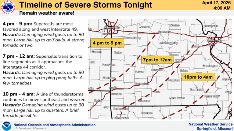
The expected timing of the system to arrive in the lake area is during the midday to overnight hours.
Additionally, there is a flood watch in effect….here is the latest on all of the info:
Flood Watches:
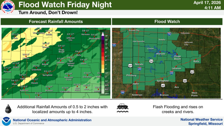
…FLOOD WATCH IN EFFECT FROM THIS EVENING THROUGH SATURDAY MORNING…
* WHAT…Flooding caused by excessive rainfall is possible.
* WHERE…Portions of southeast Kansas, including the following areas, Bourbon, Cherokee and Crawford and Missouri, including the following areas, Barton, Benton, Camden, Cedar, Dade, Dallas, Greene, Hickory, Jasper, Laclede, Lawrence, Maries, Miller,
Morgan, Newton, Phelps, Polk, Pulaski, St. Clair, Vernon and Webster.
* WHEN…From this evening through Saturday morning.
* IMPACTS…Excessive runoff may result in flooding of rivers, creeks, streams, and other low-lying and flood-prone locations.
Low-water crossings may be flooded.
…FLOOD WATCH IN EFFECT FROM 4 PM CDT THIS AFTERNOON THROUGH LATE TONIGHT…
* WHAT…Flooding caused by excessive rainfall is possible.
* WHERE…A portion of central Missouri, including the following areas, Boone MO, Callaway MO, Cole MO, Moniteau MO and Osage MO.
* WHEN…From 4 PM CDT this afternoon through late tonight.
* IMPACTS…Flooding may occur in poor drainage and urban areas. Low-water crossings may be flooded.
* ADDITIONAL DETAILS…
– A round of thunderstorms with heavy rainfall is likely Friday night. Rainfall amounts of 1-2 inches with localized amounts of 3-4 inches are possible.
PRECAUTIONARY/PREPAREDNESS ACTIONS…
You should monitor later forecasts and be alert for possible Flood Warnings. Those living in areas prone to flooding should be prepared to take action should flooding develop.

Reporter John Rogger